Showing 183 items matching geological map
-
 Greensborough Historical Society
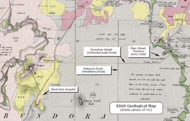
Map - Geological Map, 1868 Geological map of Greensborough (annotated), 1868_
... Geological Map...1868 Geological map of Greensborough (annotated)...This geological map from the State Library of Victoria... Plenty Lower Plenty melbourne Geological Map Map 1868 Geological ...This geological map from the State Library of Victoria collection has been annotated by GHS member Ian Bryant to show some local landmarksDigital copy of colour map.Annotations on map show locations.greensborough - maps, 1860s melbourne, suburbs, geography, roads -
 Federation University Historical Collection
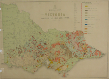
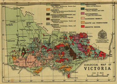
Map, Department of Mines - Victoria, Geological Map of Victoria, 1936
... Geological Map of Victoria, 1936...geological map...Printed colour geological map of Victoria.... Geological Map of Victoria, 1936 Printed colour geological map ...Printed colour geological map of Victoria.victoria, geology, map, geological map -
 University of Melbourne, Burnley Campus Archives
Map (item) - Geological map, Geological map of Melbourne & suburbs. Issued by the Department of Mines, Victoria, 1937
... Geological map...Geological map of Melbourne & suburbs. Issued by the... Boulevard Richmond melbourne Geological map Map Geological map ... -
 Federation University Historical Collection
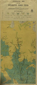
Map, Geological Map of The Stieglitz Gold Field, 1940
... Geological Map of The Stieglitz Gold Field...geological map...Rectangular geological map edged in masking tape showing... Geological Map of The Stieglitz Gold Field Rectangular geological map ...At the bottom of the 2nd page, there is text that reads "Geologically and topographically surveyed in 1909 by W.H. Ferguson, Assistant Field Geologist. Published 1940."Rectangular geological map edged in masking tape showing Steiglitz, Victoria. Scale 48 chains to 4 inches.steiglitz, geology, geological map, north albion, moreep, mining, mine, caribald reef, durdidwarrah, gilbraltar hill, mount pleasant gully, township of steiglitz -
 Federation University Historical Collection
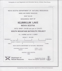
Map - Geological, Nova Scotia Department of Natural Resources, Kejimkujik Lake, Nova Scotia: Geological Map 94-05, 1994
... Map - Geological...Kejimkujik Lake, Nova Scotia: Geological Map 94-05... - Geological Kejimkujik Lake, Nova Scotia: Geological Map 94-05 Large ...Produced b Nova Scotia Department of Natural Resources, Mines and Energy Branches. The Minister of the Department was the Honourable Donald R Downe and the Deputy Minister was Darrell D HiltzLarge coloured map depicting different areas and deposits. Includes a legend, symbols used, mineral abbreviations and alteration abbreviations.Symbolsnova scotia, kejimkujik lake, geological survey, cartography, mine and energy branches, donald r downe, minister, darrell d hiltz, deputy mnister, south mountain batholith project, legend, symbols -
 Federation University Historical Collection
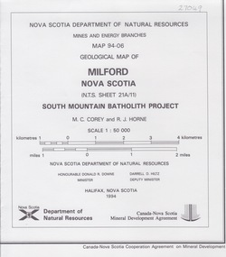
Map - Geological, Milford, Nova Scotia, Geological Map 94-06: South Mountain Batholith Project
... Map - Geological...Milford, Nova Scotia, Geological Map 94-06: South Mountain... - Geological Milford, Nova Scotia, Geological Map 94-06: South Mountain ... -
 Federation University Historical Collection
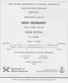
Map - Geological, New Germany Nova Scotia, Geological Map 93-01
... Map - Geological...New Germany Nova Scotia, Geological Map 93-01... - Geological New Germany Nova Scotia, Geological Map 93-01 ... -
Federation University Historical Collection
Map - Map - Geological, Kejimkujik Lake, Nova Scotia: Geological Map 94-05, 1994
... Map - Geological...Kejimkujik Lake, Nova Scotia: Geological Map 94-05... - Geological Map Kejimkujik Lake, Nova Scotia: Geological Map 94-05 ...Produced by Nova Scotia Department of Natural Resources, Mines and Energy Branches. The Minister of the Department was the Honourable Donald R Downe and the Deputy Minister was Darrell D HiltzLarge coloured map depicting different areas and deposits. Includes a legend, symbols used, mineral abbreviations and alteration abbreviations.Symbolskejimkujik lake, nova scotia -
 Federation University Historical Collection
Photograph - colour, William Baragwanath, Department of Mines: Geological map of Victoria, c1935
... Department of Mines: Geological map of Victoria...geological map... Photograph - colour Department of Mines: Geological map of Victoria ...Photograph included in book "Victoria: Gold and Minerals" issued by Mines Department Victoria, 1935Photographmap, department of mines, victoria, key to land formations, time periods, jurassic, geological map -
 Federation University Historical Collection
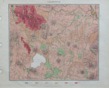
Map, Geological Map of Learmonth, 1882, 10/1882
... Geological Map of Learmonth, 1882... geological map edged in masking tape. Six colours define geology... Geological Map of Learmonth, 1882 Two copies: (printed noted attached ...Two copies: (printed noted attached) 3.) Rectangular geological map edged in masking tape. Six colours define geology and are predominantly pink. Scale 40 chains to one inch .4) Notes referring to the Geological Map of Learmonth learmonth, lake learmonth, glendaruel, burrumbeet, mt blowhard, morton's hill, mt bolan, addington, mt cavern, coghill's hill, mt hollowback, mt pisgah, weatherboard hill, webster's hill, foster's hill, mt bolen, one mile hill, vaughan's hill, tourello stattion, ballarat to maryborough railway, saddleback hill, ceres, brown's hill, ross's hill, norman taylor, robert burrows, richard shephard, james finnie -
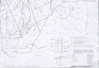 Ringwood and District Historical Society
Map - Maps, Geological Map Donvale to Chirnside Park, also Victorian Railways Maps of Hawthorn to Lilydale Line incl Ringwood to East Ringwood - 1881
... Geological Map Donvale to Chirnside Park, also Victorian...Faint photocopies of sections of larger maps. Geological...Maps Map Geological Map Donvale to Chirnside Park, also ...Faint photocopies of sections of larger maps. Geological map includes location of mine shafts circa 1920.Victory Shaft, North Victory Shaft, South Caledonia Shaft, Caledonia Shaft, North Caledonia Shaft, Black Swan Shaft, Reward Shaft, Consols Shaft, Blocks Shaft, Devonshire Shaft, Crown Shaft, Yarra Tunnel Reef Working, Bright's Shaft, Kingwood Antimony Company Shaft (Boardman's Shaft), Southern Shaft. -
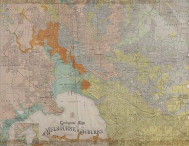
University of Melbourne, Burnley Campus Archives
Map - Geological map, Melbourne and Suburbs, 1959
... Geological map...Geological map of Melbourne in 1959 modified by officers... Boulevard Richmond melbourne Geological map Map Melbourne ...Geological map of Melbourne in 1959 modified by officers of the Geological Survey of Victoria from earlier geological surveys. Australia 1:31.680 Series.survey -
Whitehorse Historical Society Inc.
Map, Melbourne Geological Map, 1937
... Melbourne Geological Map...Geological Map of Melbourne & Suburbs. Scale: 40 chains... Mitcham melbourne Map Map Melbourne Geological Map Geological Map ...Geological Map of Melbourne & Suburbs.Geological Map of Melbourne & Suburbs. Scale: 40 chains to 1 inch with inset 10 miles to 1 inch. Includes Municipal and Parish boundaries, railways and stations, electric tramways, cable tramways, Post Offices and State schools. Area bounded by Braybrook, Preston, Blackburn & Brighton. Printed on linen.Geological Map of Melbourne & Suburbs. melbourne, maps -
Federation University Historical Collection
Map, Geological Map (Southern Western Australia)
... Geological Map (Southern Western Australia)...A section of a map showing geology and routes... Geological Map (Southern Western Australia) A section of a map ...A section of a map showing geology and routes of exploration. Southern Western Australia only western australia, perth, geology, exploration -
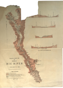 Federation University Historical Collection
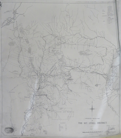
Plan, Geological Sketch Map of Portion of Big River
... Geological Sketch Map of Portion of Big River...geological sketch map... Plan Geological Sketch Map of Portion of Big River Printed map ...Printed map on paperscale, index to colours, sectionsgeological sketch map, plan, big river, mount wills, geology -
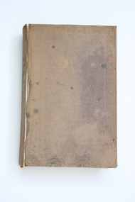 Geoffrey Kaye Museum of Anaesthetic History
Book, Longman, Brown, Green and Longmans, Physical Description of New South Wales and Van Diemen's Land. Accompanied by a geological map, sections, and diagrams, and figures of the organic remains, 1845
... Land. Accompanied by a geological map, sections, and diagrams... a handcoloured octavo folding, geological map, bound as a frontispiece... by a geological map, sections, and diagrams, and figures of the organic ...Dr. Gwen Wilson, Emeritus historian, gifted this book at ANZCA's first independent Annual Scientific Meeting held in Launceston in 1994. Dr Wilson presented this gift after her speech about the life of William Russ Pugh and his significant contribution to anaesthesia in Australia. It is unclear as to how the book came into Dr Wilson's possession. Published in London, 1845, for Longman, Brown, Green and Longmans, this book was formally owned by general practitioner Dr William Russ Pugh, being the first medical practitioner in Australia to administer ether anaesthetic on 7 June 1847, in Launceston. The author of the book, P E De Strzelecki acknowledges Pugh for his assistance during his stay in Launceston and for allowing him the use of his laboratory for the analysis of the soils and minerals that were subsequently reported in this book (Page 131). Tan coloured cloth book with an embossed circular motif on the centre of the front and back cover. The same embossed motif is repeated four times along the spine of the book. An embossed design of small, four petal flowers borders the edge of the front and back cover. The title of the book 'Strzelecki's New South Wales and Van Diemen's Land' is printed in gold on the spine. The cloth has come unstuck at various places around the spine and a small section is missing from the base of the spine. The cover is worn and has numerous dark stains possibly from mould. The book contains 19 engraved and lithographed plates. This includes a handcoloured octavo folding, geological map, bound as a frontispiece, depicting the NSW coast down to Gippsland and Tasmania, a fold out single colour geological cross section of the Newcastle Coal Basin, 14 plates illustrating shellfish and flora and three tinted lithographs. Single page maps at the back illustrate wind patterns around Australia. [front title page, two black ink stamps that have bled through to the next page] W R.PUGH [front title page, black ink, cursive writing] H Grant \ 5 May 1910 [front title page, pencil, cursive writing, written around Pugh's stamp] Purchased from \ (unrecognizable script) [front title page, previous owner's name was rubbed out and consequently tore the page making the entry unreadable] [Inner back cover, bottom LHS, blue stamp] BOUND BY \ WESTLEYS & \ CLARK \ LONDON [Inner front cover, bottom LHS, black and purple ink] P65 \ 76 \ 78 \ 98 \ 163 \ 164 \ 217strzelecki, van diemen's land, wilson, gwen, pugh, william, launceston, green and longmans -
 Federation University Historical Collection
Map - Map - Geological, Ballarat, 1858, 10/1858
... Map - Geological...Four colour geological map of Ballarat.... - Geological Map Ballarat, 1858 Four colour geological map of Ballarat ...Four colour geological map of Ballarat.map, ballarat, geology, black hill, golden point, povery point -
 Federation University Historical Collection
Map - Geological, J. Phillips, Geological Survey of Victoria - Ballarat, 1857, 10/1858
... Map - Geological...Geological map of the Ballarat District featuring four... E.J. Barker Library (top floor) Mount Helen goldfields Map ...Geological map of the Ballarat District featuring four colours.ballarat, geological, geology, geological plan -
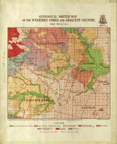 Federation University Historical Collection
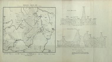
Map, Geological Sketch Map of the Werribee Gorge and Adjacent Country, 1914
... Geological Sketch Map of the Werribee Gorge and Adjacent...A coloured geological sketch map of the Werribee Gorge... Geological Sketch Map of the Werribee Gorge and Adjacent Country ...A coloured geological sketch map of the Werribee Gorge, Bacchus Marsh, Rowlesy, Darley, Parwan. The scale is 1 mile to 1 inchwerribee gorge, bacchus marsh, darley, parwan, w.e. bennett, bennett, r.a.f. murray, c.c. brittlebank, rowsley -
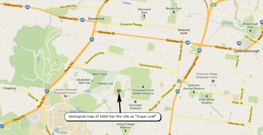 Greensborough Historical Society
Map, Overlay/comparison Map for 1868 Greensborough-Bundoora Geological Map area, 1868_
... Geological Map area.... Greensborough-Bundoora Geological Map area. Map copied from Google maps ...This map is a comparison to the map at Item 2518, questioning the location of "Sugar Loaf". Annotation by GHS member Ian Bryant.Map copied from Google maps.Annotation on map.sugarloaf hill, bundoora, greensborough - maps -
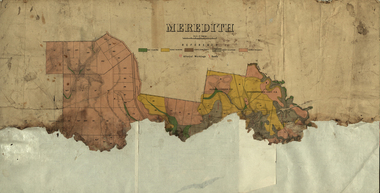 Federation University Historical Collection
Plan, Meredith Geological Map
... Meredith Geological Map... Plan Meredith Geological Map Coloured map of Meredith backed ...Coloured map of Meredith backed onto sheets of paper.meredith, borhoneyghurk pre-emptive right, borhoneyghurk east pre-emptive right -
 Federation University Historical Collection
Map, Geological Map of Ascot, 1937
... Geological Map of Ascot, 1937... Geological Map of Ascot, 1937 Coloured plan of Melbourne and suburbs ...Coloured plan of Melbourne and suburbs.melbourne, geological, geology, caulfield, brighton, box hill, camberwell, richmond, prahran, st kilda, brunswick, coburg, keilor, braybrook, kew, hawthorn, northcote, williamstown, south melbourne -
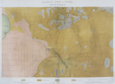
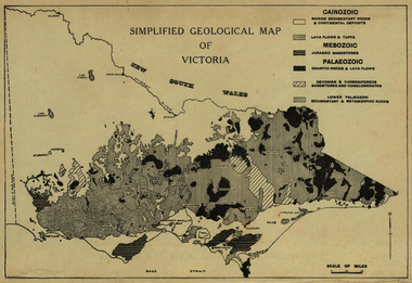 Ballarat Heritage Services
Map, Simplified Geological Map of Victoria, c1940
... Simplified Geological Map of Victoria, c1940... Office goldfields Map Simplified Geological Map of Victoria ...Physiographic map of Victoriavictoria, map, geology, geological -
Federation University Historical Collection
Map - Map - Geological, Geological Survey of Victoria - Ballarat, 09/1858
... Map - Geological...Coloured Geological Map of Ballarat, edged with masking...Map - Geological Map Geological Survey of Victoria ...Coloured Geological Map of Ballarat, edged with masking tape. The map show alluvial silt, gold drift, geological orders, volcanic, and gold workings. Scale is 8 chains to an inch. WGS 84 Centroid: 37 degrees 33 feet 33 inches south 143 degrees 52 feet 02 inches east W.E. extent: 5km NS extent: 3 kmballarat, ballaarat, geology, goldfield, phillips, j. phillips, mining -
 Federation University Historical Collection
Map, Geological Sketch Map of the Mount Lyell District, 1935, 25-09-1935
... Geological Sketch Map of the Mount Lyell District, 1935... Geological Sketch Map of the Mount Lyell District, 1935 Copy ...Copy of a plan showing mining leases around Mount Lyell, Tasmania.mount lyell, queenstown, mining, king river -
 Federation University Historical Collection
Map, Geological Sketch Map of of Dundas, Berung, and Ripon Counties
... Geological Sketch Map of of Dundas, Berung, and Ripon...Map Map Geological Sketch Map of of Dundas, Berung ...Map of the Counties of Dundas, Berung, and Riponcounty of dundas, county of berung, county of ripon, map, geology, ararat, stawell, hamilton, grampians -
 Federation University Historical Collection
Map - Geological, Tallangatta, New South Wales: 1:250,000 Geological Series, SJ 55-3, 1966
... Map - Geological...Large coloured map showing geological features, faults..., SJ 55-3, 1966 Large coloured map showing geological features ...Compiled by the Geological Survey of N.S.W., Division of Regional Geology. Topographical base compiled from Snowy Mountains Hydro Electrical Authority, Department of Lands, County maps and Snowy Lease Map. Other sheet adjoin this map. There are 13 formation sections grouped into 9 - Quaternary, Tertiary, Middle Devonian, Lower to Middle Devonian, Lower Devonian, Upper Silurian, Silurian, Upper Ordovician and Ordovician.Large coloured map showing geological features, faults, bores, rivers and mineral deposits.Scale of map, longitude and latitude, river names. "Tallangatta 1:250,00" written in black pen.tallangatta, new south wales, geological survey, topographical base, snowy mountains hydro electrical authority, department of lands, snowy lease map, department of mines, quaternary, tertiary, middle devonian, lower to middle devonian, lower devonian, uper siluran, silurian, upper ordovician, ordovician -
Stawell Historical Society Inc
Map, 1963
... Victorian Geological Map... grampians Map Victorian Geological Map Stawell Mining ...Victorian Geological Mapstawell, mining -
 Federation University Historical Collection
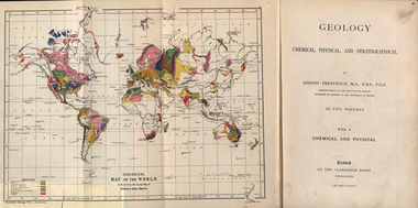
Book, Geology, Chemical, Physical, and Stratigraphical, 1886
... geological map of the world... geological map of the world geological map of europe hieropolis ...These books were added to the library of the School of Mines Ballaarat in 1889. The author was Joseph Prestwich, who was a Professor of Geology at the University of Oxford.Two brown hard cloth covered books, Vol 1 & vol 2 with gold printing on the front cover and on the spine. .1) has a coloured fold out map of the World opposite the title page .20 has a coloured fold out map of Europe..1) A label is attached to the inside front cover with The School of Mines Ballaarat and the no. 955 and date purchased 14/3/89 (1889) as well as the institutions stamp in several places throughout the book. .2) As above but with no. 956 and on the inside fly is written in pencil 'Stamped in Error' with a Ballarat School of Mines Student Library stamp crossed out.geology, bookplate, library plate, ballarat school of mines library, joseph prestwich, geological map of the world, geological map of europe, hieropolis thermal springs, rockss, ice, volvanoes, earthquakes, metallurgy, shakespeare's cliff dover, wapley, gloucestershire, redruth mining district, fossils, reptilian footprints, chalk, london clay -
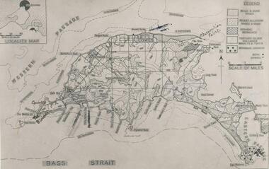 Phillip Island and District Historical Society Inc.
Photograph
... Photograph of a geological map of Phillip Island... photograph maps & mapping phillip island geology John Jenner Bryant ...One of a collection of over 400 photographs in an album commenced in 1960 and presented to the Phillip Island & Westernport Historical Society by the Shire of Phillip IslandPhotograph of a geological map of Phillip Islandlocal history, photography, phillip island map, black & white photograph, maps & mapping, phillip island, geology, john jenner, bryant west